Weather Status for August, 2020 & its verification and Outlook for September, 2020
Ten News Network
According to the National Weather Forecasting Centre/Regional Meteorological Centre, New Delhi of the India Meteorological Department (IMD):
Salient features of August, 2020
- 5 low pressure systems formed over north Bay of Bengal during 4-10, 9-11, 13-18, 19-26 and 24-31 August 2020. All these systems moved nearly west-northwestwards across central India upto West Madhya Pradesh/Rajasthan.
- The total numbers of low pressure days during August, 2020 was 27 against normal of about 15 days.
- The monsoon trough was active and south of its normal position during most days of the August, 2020.
- During August 2020, the rainfall was 27% above normal. Last such excess rain occurred in August 1983, when it was 24% above normal. So far during period 1901-2020, highest August rainfall occurred in 1926 (33% above normal) (Annexure 1)
- Due to active monsoon conditions, riverine floods occurred over Odisha, Telangana, Madhya Pradesh, Maharashtra, Gujarat and Rajasthan. The active monsoon conditions consecutively for 4 weeks leading to excess rainfall activity over the country indicated in the weekly weather videos and extended weather bulletin issued by IMD.
- Extremely heavy rainfall warnings, expected impact & suggested actions were issued 3-4 days ahead.
Major weather features of August, 2020
5 low pressure systems formed during August, 2020 and excess rainfall activity over the
country as a whole. (The details of these systems in the Attachment)
Large scale features as on 07 September, 2020
- The Madden Julian Oscillation (MJO) index lies currently over Maritime Continent (Phase 4) with weak amplitude (less than1). It is very likely to remain over Maritime Continent with weak amplitude during next 15 days.
- Currently, sea surface temperatures (SSTs) and atmospheric conditions over equatorial Pacific Ocean indicate cool El Niño-Southern Oscillation (ENSO) – neutral conditions.
- The Monsoon Mission Climate Forecasting System (MMCFS) model forecast and other global models indicate SSTs over the region to cool further. However, ENSO neutral conditions to continue during remaining part of monsoon season.
- At present, negative Indian Ocean Dipole (IOD) conditions are observed over equatorial Indian Ocean. MMCFS forecast indicates negative IOD condition will continue during rest of the season.
Rainfall Forecast for September, 2020
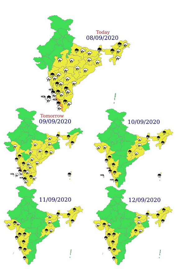
Week 1 (till 10 September, 2020)
- A Low Pressure Area lies over Eastcentral Arabian Sea off Karnataka coast with the associated cyclonic circulation extending upto 3.1 km above mean sea level. It is very likely to weaken over the same region by tomorrow, the 8 September, 2020. An eastwest shear zone runs roughly along 13°N across the cyclonic circulation associated with the above low pressure area at 3.1 km above mean sea level. It is very likely to persist during next 3-4 days. Under its influence, fairly widespread to widespread rainfall and thunderstorm & lightning very likely over Peninsular India during next 4-5 days.
Heavy rainfall at isolated places also very likely over Karnataka and Kerala & Mahe till 11 September; over Tamilnadu, Puducherry & Karaikal till 9 September, 2020.
Isolated heavy to very heavy falls also very likely over Coastal Karnataka on 9 & 10 September and over Kerala & Mahe on 8 September, 2020.
- The western end of monsoon trough at mean sea level lies near normal position and its eastern end lie north of its normal position. The eastern end of monsoon trough is likely to be north of its normal position or along the foothills of Himalayas during next 5 days.
Fairly widespread to widespread rainfall with thunderstorm & lightning and heavy rainfall at isolated places over Sub-Himalayan West Bengal & Sikkim and northeastern states till 11 September, 2020..
- Overall, rainfall is very likely to be above normal over most parts of Peninsular India and normal to above normal over Indo-Gangetic plains (Uttar Pradesh, Bihar and West Bengal).
- Rainfall is very likely to be below normal over central & adjoining East India (Annexure IV & V).
Week 2 (11-17 September 2020)
- The monsoon trough is likely to remain north of its normal position or close to the foothills of the Himalayas.
- Development of features for monsoon withdrawal from western parts Rajasthan likely during the week.
- Formation of low pressure area is unlikely.
- Above normal rainfall activity likely over northeastern states, Maharashtra, Goa, Karnataka and Kerala.
- Below normal rainfall activity is likely over remaining parts of the country with significant reduction in rainfall activity over northwest India.
Week 3 (11-17 September 2020)
- Rainfall is very likely to be above normal over extreme south Peninsular India, Andaman & Nicobar Islands, Gujarat and northern parts of Maharashtra.
- Rainfall is very likely to be near normal/below normal over rest parts of the country.
Week 4 (11-17 September 2020)
- Rainfall is very likely to be above normal along west coast, Andaman & Nicobar Islands, Gujarat and northern parts of Maharashtra, Madhya Pradesh and Uttar Pradesh.
- Rainfall is very likely to be below normal over south Peninsular India and near normal over rest parts of the country.
FORECAST FOR THE NEXT 5 DAYS: