
Isolated extremely heavy falls also very likely over Odisha on 25 & 26 and over Chhattisgarh on 27 August, 2020
Ten News Network
According to the National Weather Forecasting Centre/Regional Meteorological Centre, New Delhi of the India Meteorological Department (IMD):
Significant Weather Features Dated on 25-08-2020 (MID-DAY)
♦️ The Low Pressure Area over North Bay of Bengal &neighbourhood now lies as a Well Marked Low Pressure Area over the same region. It is very likely to move west-northwestwards during next 4-5 days.
Under its influence:
Widespread rainfallwith isolated heavy to very heavy falls very likely over Odisha, Gangetic West Bengal, Jharkhand till 28 August; over Chhattisgarh, Madhya Pradesh & West Rajasthan during 26 to 28 August, 2020. Isolated extremely heavy falls also very likely over Odisha on 25 & 26 and over Chhattisgarh on 27 August, 2020.
♦️ The other Low Pressure Area now lies over Southwest Rajasthan & adjoining Pakistan. It is very likely to merge with heat low during next 2 days.
Under the influence of the above system:
Widespread rainfall with isolated heavy to very heavy falls very likely over Gujarat state and heavy falls over southwest Rajasthan on 25 August.
♦️ The monsoon trough is active and south of its normal position. It is likely to remain active during next 2-3 days. In addition, there is a convergence of lower level southwesterly winds from Arabian Sea over northwest India till 28 August. As a result,
widespread rainfall with isolated heavy to very heavy falls very likely over northwest India till 28 August, 2020.
Weather Warning during next 5 days *
25 August (Day 1):
♦ Heavy to very heavy rainfall at a few places with extremely heavy falls at isolated places very likely over Odisha; heavy to very heavy rainfall at isolated places over West Rajasthan and heavy rainfall at isolated places over Jammu & Kashmir, Ladakh, Gilgit-Baltistan, Muzaffarabad, Himachal Pradesh, Uttarakhand, north Punjab, Chhattisgarh, Jharkhand, Gangetic West Bengal, Assam & Meghalaya, Nagaland, Manipur, Mizoram & Tripura, Gujarat state, Coastal Andhra Pradesh &Yanam and interior Tamilnadu.
- Moderate thunderstorm accompanied with lightning at isolated places very likely over West Rajasthan, Jharkhand, Gangetic West Bengal, Assam & Meghalaya, Nagaland, Manipur, Mizoram & Tripura, Coastal Andhra Pradesh &Yanam, Telangana, Tamilnadu, Puducherry &Karaikal and Kerala &Mahe.
- Strong Wind (speed reaching 50-60 kmph) very likely over Southwest & adjoining Westcentral Arabian Sea; (wind speed reaching 45- 55 kmph) over North Arabian sea and along & off Gujarat coast and North Bay of Bengal along & off Odisha-West Bengal coasts. Fishermen are advised not to venture into thesearea.
26 August (Day 2):
♦ Heavy to very heavy rainfall with extremely heavy falls at isolated places very likely over Odisha; heavy to very heavy rainfall at isolated places over Himachal Pradesh, Uttarakhand, Chhattisgarh and Jharkhand and heavy rainfall at isolated places over Jammu & Kashmir, Ladakh, Gilgit-Baltistan, Muzaffarabad, Punjab, Haryana, Chandigarh & Delhi, Uttar Pradesh, West Rajasthan, East Madhya Pradesh, Vidarbha, Bihar, West Bengal & Sikkim, Assam & Meghalaya, Telangana and Tamilnadu, Puducherry &Karaikal.
- Moderate to severe thunderstorm accompanied with lightning at isolated places very likely over Jammu & Kashmir, Ladakh, Gilgit- Baltistan, Muzaffarabad, Himachal Pradesh, Uttarakhand, Punjab, Haryana, Chandigarh & Delhi, Uttar Pradesh, Rajasthan and Moderate thunderstorm accompanied with lightning at isolated places over Bihar, Jharkhand, Assam & Meghalaya, Nagaland, Manipur, Mizoram & Tripura, Coastal Andhra Pradesh &Yanam, Telangana, Tamilnadu, Puducherry &Karaikal and Kerala &Mahe.
- Strong Wind (speed reaching 50-60 kmph) very likely over Southwest & adjoining Westcentral Arabian Sea; (wind speed reaching 45- 55 kmph) over North Bay of Bengal along & off Odisha-West Bengal coasts. Fishermen are advised not to venture into thesearea.
27 August (Day 3):
♦ Heavy to very heavy rainfall with extremely heavy falls at isolated places very likely over north Chhattisgarh; heavy to very heavy rainfall at isolated places over Uttarakhand, Uttar Pradesh and East Madhya Pradesh and heavy rainfall at isolated places over Jammu & Kashmir, Ladakh, Gilgit-Baltistan, Muzaffarabad, Himachal Pradesh, Punjab, Haryana, Chandigarh & Delhi, West Rajasthan, West Madhya Pradesh, Vidarbha, Jharkhand, Odisha and Gujarat region.
- Moderate to severe thunderstorm accompanied with lightning at isolated places very likely over Jammu & Kashmir, Ladakh, Gilgit- Baltistan, Muzaffarabad, Himachal Pradesh, Uttarakhand, Punjab, Haryana, Chandigarh & Delhi, Uttar Pradesh, Rajasthan and Moderate thunderstorm accompanied with lightning at isolated places over Coastal Andhra Pradesh &Yanam and Tamilnadu, Puducherry &Karaikal.
- Strong Wind (speed reaching 50-60 kmph) very likely over Southwest & adjoining Westcentral Arabian Sea; (wind speed reaching 45- 55 kmph) over North Bay of Bengal along & off Odisha-West Bengalcoasts.
28 August (Day 4):
♦ Heavy to very heavy rainfall at isolated places likely over Uttarakhand, Uttar Pradesh, Gujarat region and Madhya Pradesh and heavy rainfall at isolated places over Punjab, Haryana, Chandigarh & Delhi, Rajasthan,Vidarbha, Chhattisgarh, Arunachal Pradesh, Assam & Meghalaya and Nagaland, Manipur, Mizoram & Tripura.
♦ Moderate thunderstorm accompanied with lightning likely at isolated places over Rajasthan and Tamilnadu, Puducherry &Karaikal.
♦ Strong Wind (speed reaching 50-60 kmph) likely over Southwest & adjoining Westcentral Arabian Sea. Fishermen are advised not to venture into these area.
29 August (Day 5):
♦ Heavy to very heavy rainfall at isolated places likely over East Rajasthan and Gujarat region and heavy rainfall at isolated places over Uttarakhand, West Uttar Pradesh, West Rajasthan, Madhya Pradesh, Arunachal Pradesh, Assam & Meghalaya, Saurashtra & Kutch, Konkan & Goa and Tamilnadu, Puducherry &Karaikal.
♦ Moderate thunderstorm accompanied with lightning likely at isolated places over Rajasthan and Tamilnadu, Puducherry &Karaikal.
♦ Strong Wind (speed reaching 50-60 kmph) likely over Southwest & adjoining Westcentral Arabian Sea. Fishermen are advised not to venture into these area.
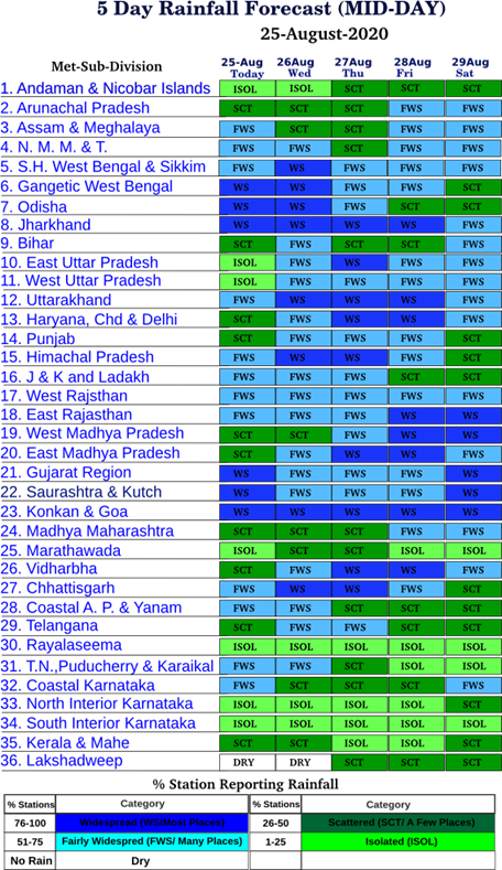
Table-1
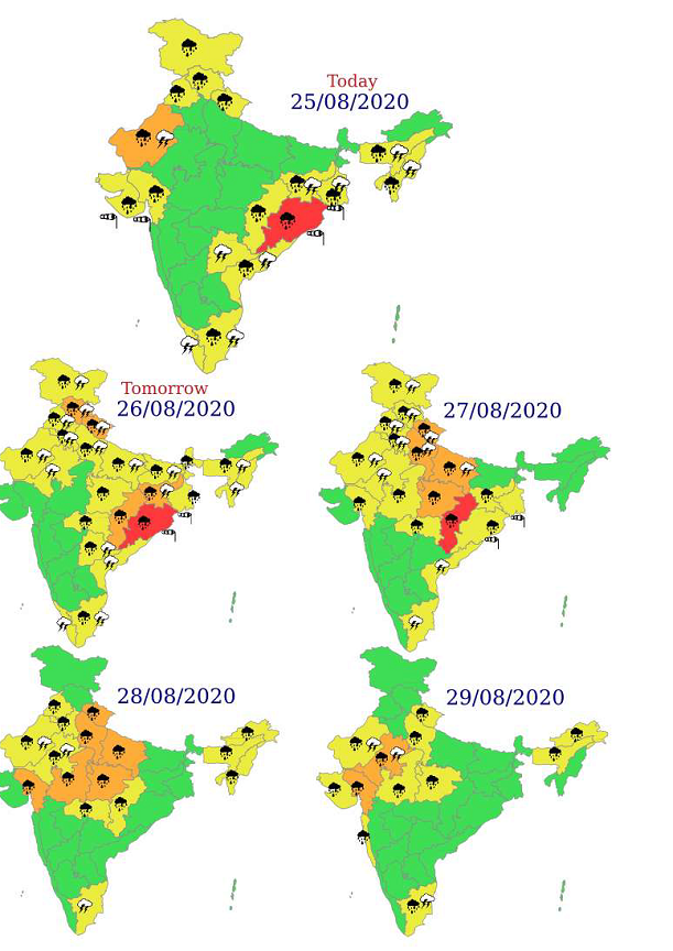
Figure- Met Sub-division wise warning for next 5 days
Impact expected over Odisha due to heavy rainfall
· Localized Flooding of roads, water logging in low lying areas and closure of underpasses
mainly in urban areas of the above region.
· Occasional reduction in visibility due to heavy rainfall.
· Disruption of traffic in major cities due to water logging in roads leading to increased
travel time.
· Minor damage to kutcha roads.
· Possibilities of damage to vulnerable structure.
· Localized Mudslides.
· Damage to horticulture and standing crops in some areas due to inundation.
· It may lead to riverine flooding in some river catchments (for riverine flooding please visit
website of center water commission (http://www.cwc.gov.in/))
For specific district wise impact kindly visit IMD’s sate level meteorological center
websites (https://mausam.imd.gov.in/imd_latest/contents/departmentalweb.php) and
national website (https://mausam.imd.gov.in/).
Action Suggested
· Check for traffic congestion on your route before leaving for your destination.
· Follow any traffic advisories that are issued in this regard.
· Avoid going to areas that face water logging problem often.
· Avoid staying in vulnerable structure.
Impact expected over Gujarat, Odisha and West Bengal coasts
· Sea conditions will be rough to very rough
· Strong Wind speed about 45-55 kmph.
Action Suggested
· Fishermen are advised not to venture into these area.
